

Drone Land Survey in London & Essex
Map your entire site from the air with accurate aerial imagery of its features, boundaries, layout and extent — captured quickly and with minimal disruption.
Request a quoteA clear, up-to-date picture of the whole parcel.
A drone land survey gives you a clear, up-to-date picture of a whole parcel of land from above — ideal whether you're assessing a site for purchase, planning a development, managing a farm or keeping accurate land records. Working across London, Essex, Hertfordshire, Kent and the wider South East, we use a professional survey-grade drone to give you reliable aerial data you can plan and make decisions from. It sits within the wider drone surveying we fly.
Our service delivers a complete overhead view of your land, supporting site planning, boundary and feature mapping, and record-keeping with real speed and minimal disruption. Every flight is carried out in line with CAA regulations and the UK Drone Code.
How a drone land survey works
Initial Enquiry
Get in touch with the location of your site and roughly what you need the survey for — a purchase, a development, farm planning or land management. We confirm the extent of the parcel, the access arrangements and the outputs that will actually be useful, then send a clear, no-obligation quote. Parts of Essex sit close to airfields such as North Weald and Stapleford, so we plan the flight and check airspace across the whole parcel from the outset.
Shoot Day
On the day, our operator attends with a professional survey-grade drone and flies a planned pattern across the whole parcel, capturing the features, boundaries and layout of the land. We work methodically so every part is covered. Flights are quick and low-disruption — no heavy equipment, no vehicles across your land and nothing trampled — making it well suited to working farms and sensitive sites.
Analysis & Evaluation
Back at base we sort and process the imagery into your chosen outputs — clear stills, mapped plans, video and any measured products agreed — and pull the key observations into a written summary. You receive clean, usable data rather than a folder of raw files, and we are happy to walk you through what the survey shows so you can move forward confidently.
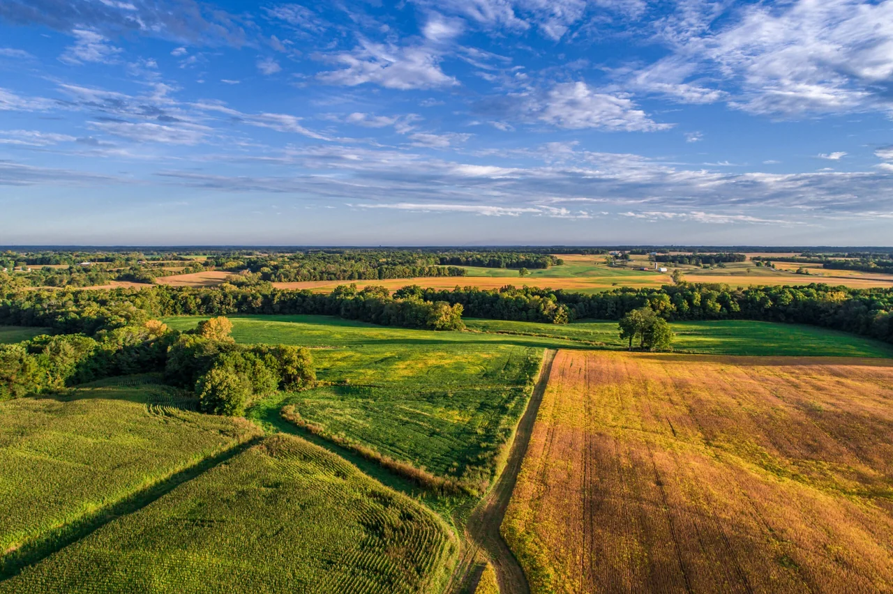
What a drone land survey maps across your site
Land drone surveying gives property owners, developers, farmers and land managers a fast, accurate way to understand a whole site from above. Instead of a ground team walking a parcel piece by piece, our survey-grade drone captures the entire extent in a single visit — its shape, boundaries, features and how it relates to the land around it — and turns that into practical outputs you can use for planning, presentations and record-keeping.
It suits anyone who needs a current, reliable picture of a site: developers sizing up a plot before designing a scheme, farmers mapping fields, tracks and drainage across large holdings, buyers and sellers wanting clear evidence of a parcel's extent, and estate managers keeping accurate records. Wherever ground access is limited, sensitive or simply large, an aerial survey gives you the complete view without the disruption.
Aerial land survey vs walking the parcel
A traditional ground survey shows a site piece by piece and takes time, heavy equipment and boots across the land. A drone maps the same parcel from the air in a fraction of the time, without vehicles or trampled ground, and gives you the entire site — boundaries, features and context — in a single clear view. Waterlogged fields, dense vegetation, steep banks and land that's hard to walk are no obstacle from above, so nothing important gets missed.
The result is stronger, more usable evidence for your decisions. High-resolution imagery and mapped plans give you solid visual documentation to support planning applications, sales, land management and conversations with agents or authorities. And because we're based in Epping and know the ground and the airspace across London, Essex and the South East first-hand, your survey is planned properly from the very start.

What an orthomosaic is, and what you can measure from it
The word comes up in every quote we send for a land survey, so here is the plain version.
When a drone flies a parcel it takes hundreds of overlapping photographs. Each one is taken from a slightly different position, so each one has a slightly different perspective — objects lean, and distances across the frame are not consistent. An orthomosaic is what you get when those photographs are stitched together and corrected so that the perspective is removed and the scale is even across the whole image. The result looks like a single enormous top-down photograph of your site, except that unlike a photograph, distances across it are consistent — so you can measure from it.
What you can do with it: measure approximate distances and areas across the parcel, check the extent and shape of a site, set out a proposed layout over the top of the real ground, compare the same site at two points in time, and hand a planning consultant or an agent something far more useful than an aerial photo pulled off a mapping site.
What we will not claim it does: it is a scaled image, not an engineering-grade measured survey. It is suitable for measuring approximate area and extent, and that is the honest description. If your decision depends on precise levels, contours and spot heights — drainage, cut-and-fill, gradients for access — that is a drone topographic survey, which is a different job with a different output. If your decision depends on legally defined boundaries, that is a matter for your title plan and your solicitor; what we give you is clear, dated visual evidence of what is actually on the ground, which is often exactly what the argument was missing.
The accuracy achievable depends on the site, the flight plan and the level of detail agreed at the briefing stage. We will tell you before we fly what the survey will and will not show.
What you receive — imagery, plans and a scaled orthomosaic
Every survey is scoped to your project — you receive the outputs that are useful to you, agreed before we fly.
High-resolution aerial imagery
Sharp overhead and angled stills showing features, access points, structures and how the parcel sits within its surroundings.
Annotated site map or plan
A clear plan-view map with key features marked up, useful for planning applications, land management and sharing.
Aerial video walkthrough
Smooth footage flying the boundary and interior of the site, giving a full sense of scale, layout and condition.
Written survey summary
A plain-English report describing what was captured and notable features across the site, easy to hand on to others.
Orthomosaic / measured area map
A stitched, scaled top-down image suitable for measuring approximate area and extent across the parcel.
3D site model
A three-dimensional model of the land and its features for visualisation and design context.
What drives the cost of a drone land survey
Your quote is based on the property or site, the access available and the outputs you need. Send us the address, the question you want answered and any deadline. We will confirm the proposed scope and price before you decide whether to book.
What happens on survey day
Before we attend. We confirm the extent of the parcel with you — ideally a plan, a title plan or even a marked-up screenshot, because "the field behind the barn" means different things to different people. We then map the airspace across the whole site, not just the middle of it, because on a large parcel the edges can sit in different airspace from the centre.
On arrival. Our operator finds a safe launch point with clear sightlines and walks enough of the site to understand the ground. On a working farm we will ask about livestock, machinery movements and anything nesting before we put anything in the air.
The flight. The drone flies a planned grid across the parcel with the overlap the stitching needs — this is why it is a pattern rather than a wander. Larger sites are flown in several passes with battery changes between them. Nothing drives across your land, nothing gets trampled, and no gates get left open.
Before we leave. We check coverage on site. A gap in the middle of an orthomosaic cannot be fixed at the desk, so if a pass needs re-flying it gets re-flown before we pack up.
You do not need to be on site while we fly, though you are welcome to be. What we do need is access to the ground we will take off and land from, and a reasonably calm, dry window — drones need decent conditions to fly safely and capture clean data, so occasionally we will move a date rather than fly in the wrong weather and give you imagery you cannot use. If a date has to move, we tell you as early as we can.
Your deliverables and their formats
| Deliverable | Format | Notes |
|---|---|---|
| Aerial imagery | High-resolution JPEG | Overhead and angled, showing features, access and context |
| Annotated site map or plan | PDF, plus source image | Key features marked up for planning, management or sharing |
| Aerial video walkthrough | MP4 | Boundary and interior passes, for scale and condition |
| Written survey summary | Plain English, describing what was captured and what stands out | |
| Scaled orthomosaic | GeoTIFF and high-resolution JPEG | For measuring approximate area and extent |
| 3D site model | Agreed at briefing | For visualisation and design context |
Turnaround. The flight is usually a single visit. Imagery, video and the written summary typically follow within a few days. A stitched orthomosaic or a 3D model takes longer because there is genuine processing behind it — on a large parcel, meaningfully longer — and we will give you a date at the briefing rather than a vague promise.
If your planning consultant, agent or design team needs a particular file type or coordinate reference, tell us at the briefing and we will match it where we can.
Aerial land survey vs a ground team walking the parcel
| Ground survey on foot | Drone land survey | |
|---|---|---|
| Coverage | Piece by piece, in the order the ground allows | The whole parcel, flown to a plan, in one visit |
| Difficult ground | Waterlogged fields, dense scrub, steep banks and blocked tracks slow it right down or stop it | Irrelevant — it is all flown from above |
| Impact on the land | Vehicles, boots, gates, crops | Nothing crosses your land |
| Time | Days on a large holding | A single visit for most parcels |
| What you end up with | Notes, measurements and a plan | Imagery, video, an annotated plan and a scaled orthomosaic you can measure from |
| Context | The parcel in isolation | The parcel and how it sits against neighbouring land, roads and access |
That last row is the one people underestimate. A great deal of what a land survey is really being asked to settle — where the access actually comes off, what the neighbour has built up to the line, how the drainage runs across the boundary — is only visible when you can see the parcel and its surroundings in one frame.
Why map land by drone
See the whole parcel at once
From the air you get the entire parcel — its shape, boundaries, features and how it relates to neighbouring land — in a single, clear view.
Fast turnaround, little disruption
A drone maps a large site in a fraction of the time of a walking survey, without heavy equipment, vehicles or trampled ground.
Reach difficult ground
Waterlogged fields, dense vegetation, steep banks or land you can't easily walk are no obstacle from above.
Clear evidence for planning
High-resolution imagery and mapped plans give strong documentation for planning applications, sales and land management.
A local team who knows the area
Based in Epping and covering London, Essex and the South East, we bring genuine local knowledge of the ground and airspace.
Who commissions a drone land survey
Land surveys across Essex, Hertfordshire and the South East
We are based in North Weald, Epping, and we cover London, Essex, Hertfordshire, Kent and the wider South East. Being local matters more than it sounds: much of this patch sits under controlled airspace or close to aerodromes such as North Weald Airfield and Stapleford, so knowing the ground and the airspace means permissions are handled early and your survey is planned properly from the first phone call rather than the day before.
Most of our land work is across Essex and the Herts border — Epping, North Weald, Roydon, Harlow, Chipping Ongar, Waltham Abbey, Great Dunmow, Stansted Mountfitchet, Braintree, Maldon, Chelmsford, Billericay, Brentwood, Basildon, Colchester, Thurrock and Grays — plus development plots across Greater London, and holdings across Hertfordshire, Kent and the wider South East.
A good deal of this ground sits under the airspace around North Weald Airfield and Stapleford Aerodrome, and a large parcel can straddle more than one zone. We map that before we attend, not on the day.
Not sure whether we cover you? Check we cover your site →
Land survey or topographic survey — which do you need?
A land survey answers "what is here, and how big is it?" Boundaries, features, structures, tracks, drainage runs, access points, vegetation, and how the parcel sits against its neighbours. You get imagery, an annotated plan and a scaled orthomosaic you can measure approximate areas from.
A topographic survey answers "how does the ground rise and fall?" Contours, spot heights, gradients — delivered as a scaled topographical drawing your engineer or architect can design from. If the words in your brief are drainage, levels, cut-and-fill, falls or gradients, that is the one you need.
Many clients do both, in that order: a land survey to understand a site while they are still deciding whether to buy it, then a topographic survey once a scheme is being designed. If you are commissioning both, tell us — they can often be flown in the same visit.
Drone land surveys — your questions answered
What exactly does a drone land survey capture?
A drone land survey maps a parcel of land from above — its features, layout, access points, structures, boundaries and overall extent. It gives you a complete, current picture of the site as a whole, ideal for property, development, agriculture and land management. If you need precise engineering-grade contours, levels and spot heights, that's a topographic survey, which we also offer as a separate service.
How is this different from a topographic survey?
A land survey is about mapping what's there across the parcel — the features, boundaries and extent. A topographic survey goes further into precise ground levels, contours and gradients to scale, for engineers, architects and designers. Many clients start with a land survey to understand a site, then commission a topographic survey once they're moving into detailed design.
How large a site can you survey by drone?
Drones are very well suited to large parcels — from a single field or plot up to sizeable holdings and estates. Larger sites are simply flown across several planned passes. When you get in touch, let us know the rough size and location and we'll confirm what's involved and quote accordingly.
Will bad weather or difficult ground stop the survey?
Drones need reasonably calm, dry conditions to fly safely and capture clear data, so occasionally we'll reschedule for weather. Difficult ground, on the other hand, is where drones shine — waterlogged, overgrown or hard-to-walk land that's awkward for a ground team is straightforward to map from the air.
Are there airspace restrictions on land surveys in Essex?
Rural land often sits under the approach paths and airspace around airfields such as North Weald Airfield and Stapleford Aerodrome, and large parcels can straddle more than one airspace zone. Because a land survey means flying the full extent of a parcel, we map the airspace across the whole site before we attend and plan the passes so every part is captured safely and legally. If a location needs particular care or permissions, we'll tell you upfront.
How much does a drone land survey cost?
The right cost depends on the size of the parcel, its location and the outputs you need. Because sites vary so much, we quote each land survey individually — tell us about your site and you'll get a clear, no-obligation quote, with no figure committed until we understand what you need.
How large a parcel can you survey in one visit?
Larger than most people expect. A single field or plot is one short flight; sizeable holdings and estates are flown across several planned passes with battery changes between them, still usually within a single visit. Tell us the rough acreage and the location when you enquire and we will confirm what is involved before quoting.
Can I measure areas from what you give me?
From the scaled orthomosaic, yes — for approximate area and extent, which is what most planning, management and agency work needs. It is not an engineering-grade measured survey and we will not describe it as one. If you need precise levels and contours, that is a topographic survey.
Can a drone land survey settle a boundary dispute?
It can give you much better evidence than you had. Clear, dated, high-resolution overhead imagery showing exactly what is on the ground — fences, hedges, structures, hardstanding, where the access actually runs — is often the missing piece in an argument that has been conducted from memory and a photocopied plan. What it cannot do is determine the legal boundary; that comes from your title plan and your solicitor. We give you the picture; they apply the law to it.
Will you fly over my neighbour's land?
We plan the flight around the parcel you have asked us to survey. Where a pass has to cross adjoining land to get the coverage the survey needs, we handle that within CAA regulations and the UK Drone Code, and we tell you in advance if it is a factor. We do not go looking over the fence for its own sake.
Can you survey the same site again later to show what has changed?
Yes, and it is one of the strongest things a drone land survey does. Fly the same parcel to the same plan six or twelve months apart and you have a like-for-like visual record of change — useful for development monitoring, land management, environmental work and any conversation where "it did not used to look like that" needs backing up. Repeat visits to a site we already know are quicker to set up.
Is there anything a drone land survey will not tell me?
Yes, and we would rather say so now. It records what is visible from above at the moment we fly. It will not tell you what is under the ground, it will not tell you where the legal boundary runs, and dense tree canopy in full leaf will hide what is underneath it — which is occasionally a reason to survey in winter instead. If any of those matter to your decision, tell us at the briefing and we will be straight about whether this is the right survey.
Related surveys we fly



Ready to elevate your surveying experience?
Tell us about your site and what you need the survey for, and we'll come back with a clear, no-obligation quote for a drone land survey across London, Essex and the South East.
Talk to the team